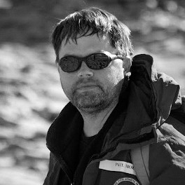
Paul Morin, PHD

Bio: Morin leads a team of two dozen responsible for imaging, mapping and monitoring the Earth’s polar regions for the National Science Foundation’s Division of Polar Programs. Morin is the liaison between the National Science Foundation and the National Geospatial-Intelligence Agency’s commercial imagery program.
Before founding PGC, Morin was at the National Center for Earth-Surface Dynamics at the University of Minnesota, and he has worked at the University of Minnesota since 1988. Morin serves as the National Academy of Sciences–appointed U.S. representative to the Standing Committee on Antarctic Geographic Information under the Scientific Committee for Antarctic Research (ie, the Antarctic Treaty System). One of his current projects is ArcticDEM, a White House initiative to produce a high-resolution, time-dependent elevation model of the Arctic using Blue Waters.
Morin’s professional interests include mapping areas of the Earth that are difficult to reach, scientific visualization and using scientific art for formal and informal education. Morin has dozens of publications in a variety of fields including remote sensing, geoscience education, the carbon cycle, and scientific visualization. In 2015 Morin was awarded an honorary doctorate at Colorado College for his outstanding contributions in the Geoscience field. Morin’s art/visualizations have been in numerous publications including National Geographic, Nature and Wired. He has contributed to the BBC/David Attenborough production “Frozen Planet” and is spearheading the effort with Google to improve polar geospatial data, imagery and Street View in Google Earth and Maps. Morin is coauthor on the number one selling introductory geology textbook “Exploring Geology” and the newly released “Exploring Earth Science.” Morin was born and raised in Minnesota and he resides in St. Paul with his wife and two children.
Contact Info:
R280 Learning & Environmental Sciences
1954 Buford Avenue
Saint Paul, MN 55108 USA
Work: 612-625-6090
